


In the Takeuchi laboratory, remote sensing technology has been using for the application areas such like atmospheric environment, high carbon reservoirs and urban environment. For this case, the objects are detected by various sensors and modeling can be done by extracting the useful information from the captured data.
The spatial scale is varying from urban/local to global level. The sensors named according to the wavelength they are used in the electromagnetic spectrum such as hyper-spectrum, visible, near infrared, thermal infrared and microwave and use relevant data based on the purpose of the application and objects.
[Publication]Journal papers and presentations are listed here
[Research category] Atmosphere / Carbon sequestration | Agriculture | Urban environmental assessment | Infrastructure health monitoring | Natural disaster | Field survey
Atmosphere / Carbon sequestration
In recent years, increase of green house gas emission and air pollution became a serious problem in the world. In this case, anthropogenic impact is significant in the context of urbanization, forest fire for cultivation and land reclamation on coastal ecosystem and wetlands. Understanding the reciprocal relationship among the CO2 source and pools and the terrestrial ecosystem and atmospheric environment is necessary to solve the problem.
In our laboratory, we extract ecological parameters from satellite data and estimate terrestrial/coastal CO2 and CH4 for wetlands.
 |
 |
 |
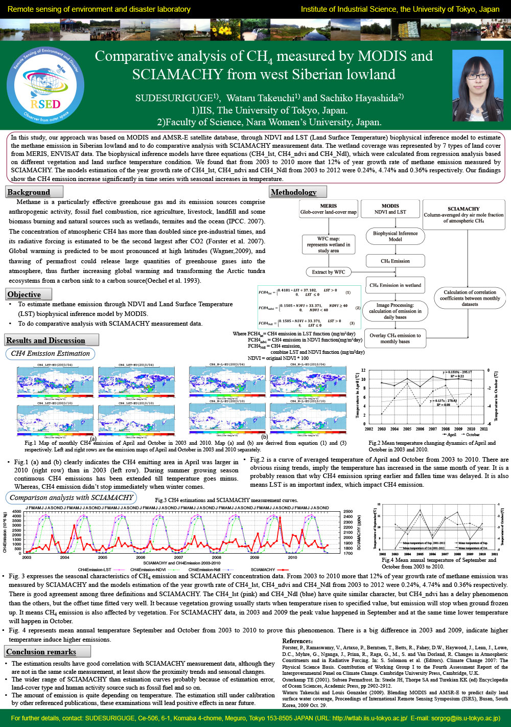
Comparative analysis of CH4 measured by MODIS and SCIAMACHY from west Siberian lowland [PDF] |
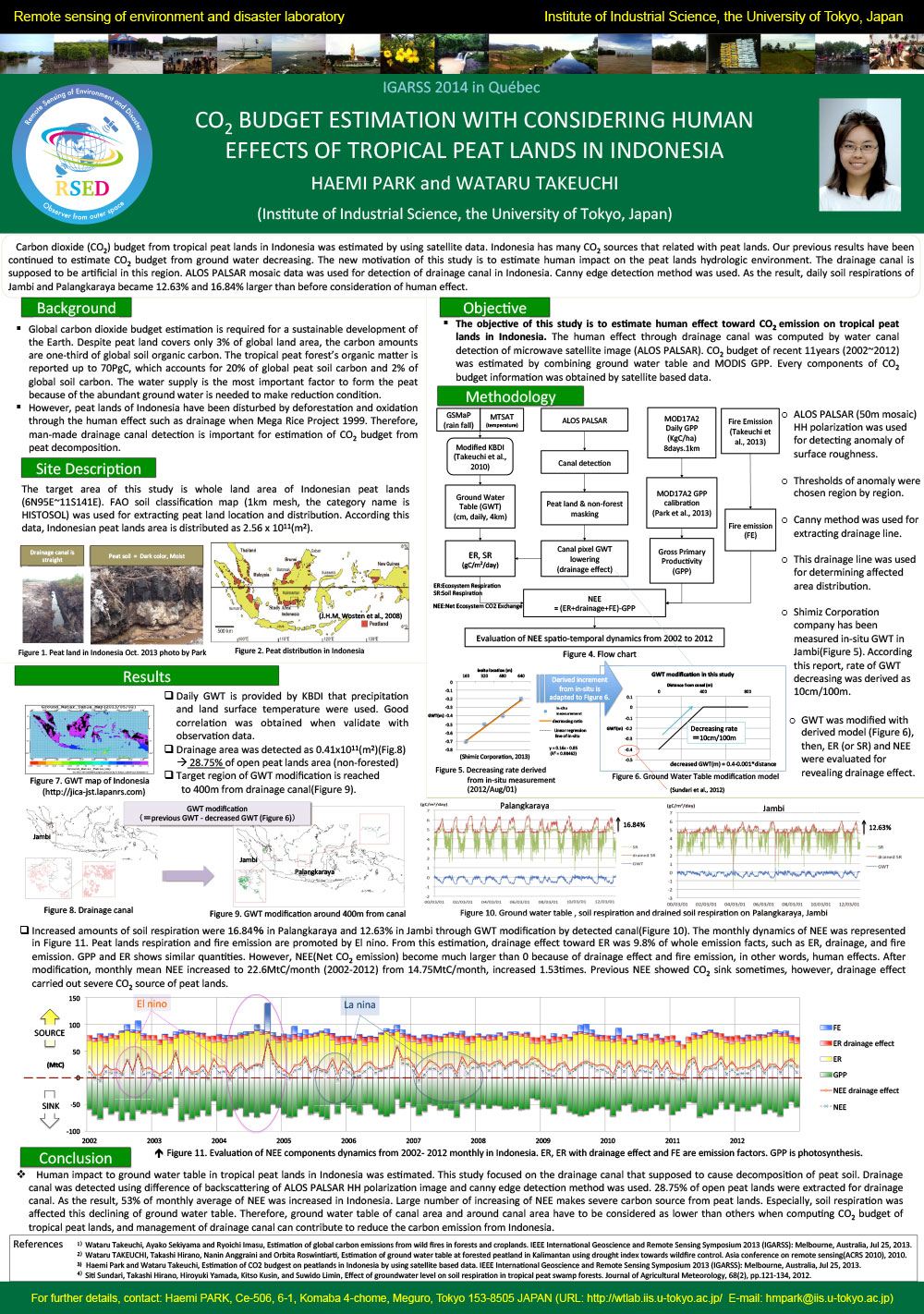
CO2 budget estimation with considering human effects of tropical peat lands in Indonesia [PDF] |
Effects of Damming on Seagrass Distribution Near Mekong River Mouth [PDF] |
 |
 |
 |
||
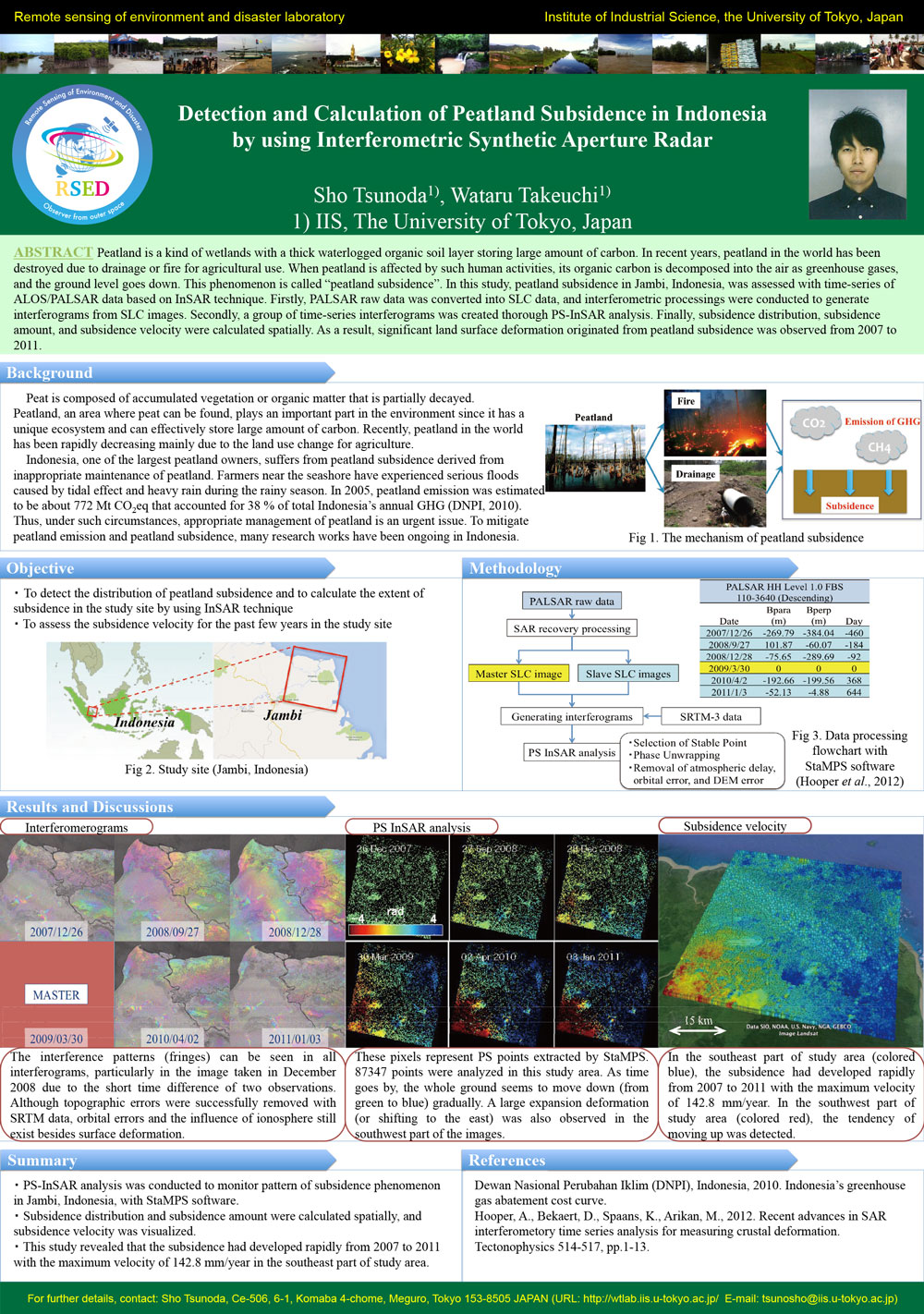
Detection and calculation of peatland subsidence in Indonesia by using Interferometric Synthetic Aperture Radar [PDF] |
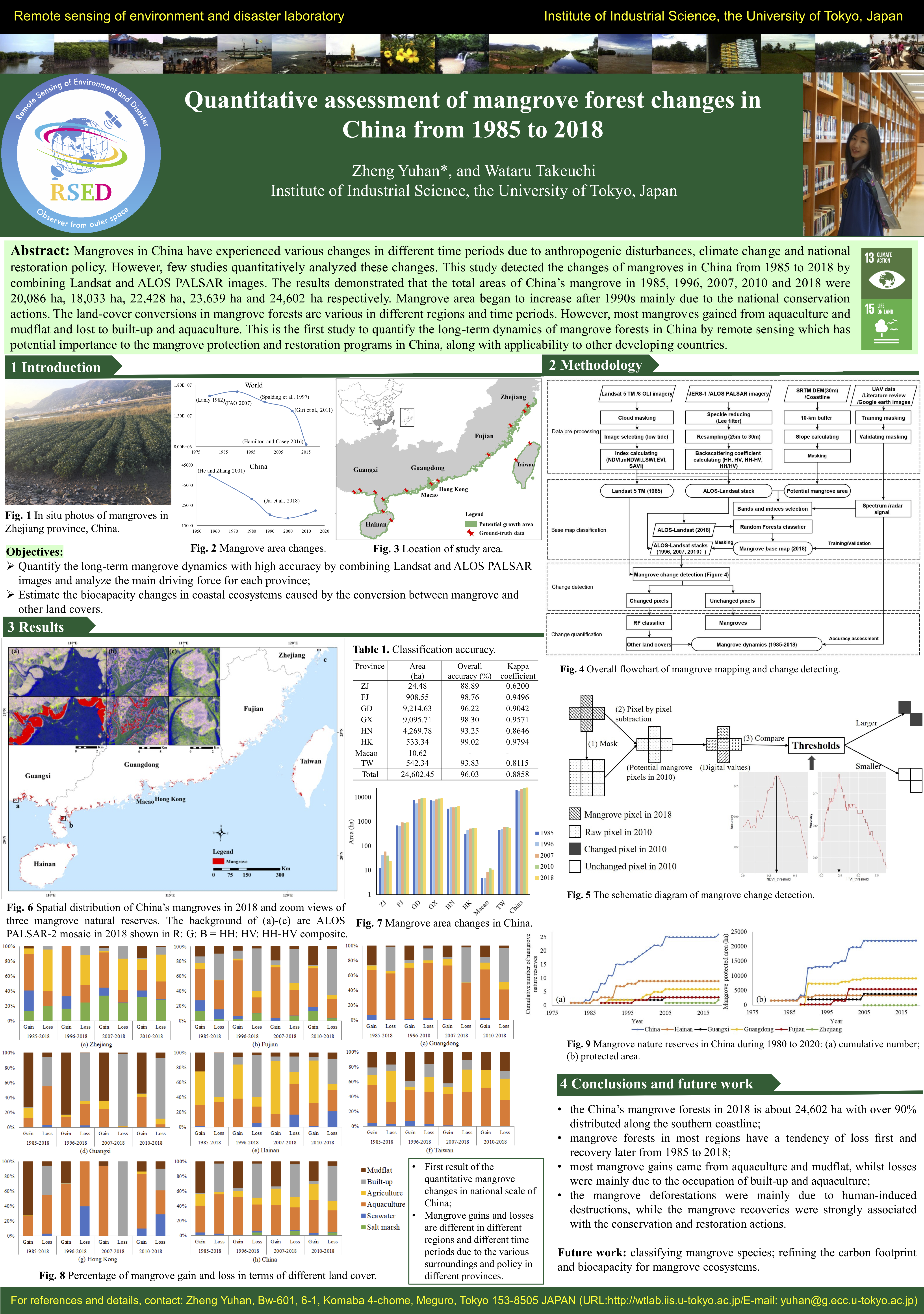
Quantitative assessment of mangrove forest changes in China from 1985 to 2018 [PDF] |
Spatiotemporal Distribution of Potential Human-Elephant Conflict Hotspots in Eastern Thailand [PDF] |
 |
 |
 |
||
Estimation of optimal canopy shape on a tropical broadleaf forest [PDF] |
Seagrass mapping on an intertidal flat at different tide levels using UAV and Sentinel-2 [PDF] |
Mongolia Grassland Sustainability Evaluation Through Its Responsiveness to Precipitation From 2001 to 2019 [PDF] |
 |
 |
 |
||
Development of Groundwater Table Depth Estimation Method for Tropical Peatland [PDF] |
Satellite-based modeling of gross primary production and net ecosystem exchange in mangrove ecosystems [PDF] |
Country-wide human-elephant conflict risk assessment under future climate-induced changes in Thailand [PDF] |
 |
 |
 |
Tracking the Trajectories of Peatland Drainage: A National-Scale Canal Development Trend in Indonesian Peatlands (2007–2023) [PDF] |
Predicting the Malayan tapir presence and their responses to anthropogenic activities in Peninsular Malaysia using remote sensing [PDF] |
Applying MaxEnt to Predict the Future Distribution of Human-Black Bear Conflicts in Toyama and Akita Prefectures, Japan [PDF] |
 |
 |
 |
Computer simulation of boreal forest spectra with asymmetric canopy shape in far earstern Russia [mp4] |
Satellite-based modeling of net ecosystem exchange in mangrove ecosystems considering the effects of sea surface temperature, salinity and solar irradiation [mp4] |
Integration of Sentinel-2 and UAV images to estimate the influence of tidal stages on seagrass photosynthesis [mp4] |
 |
 |
|
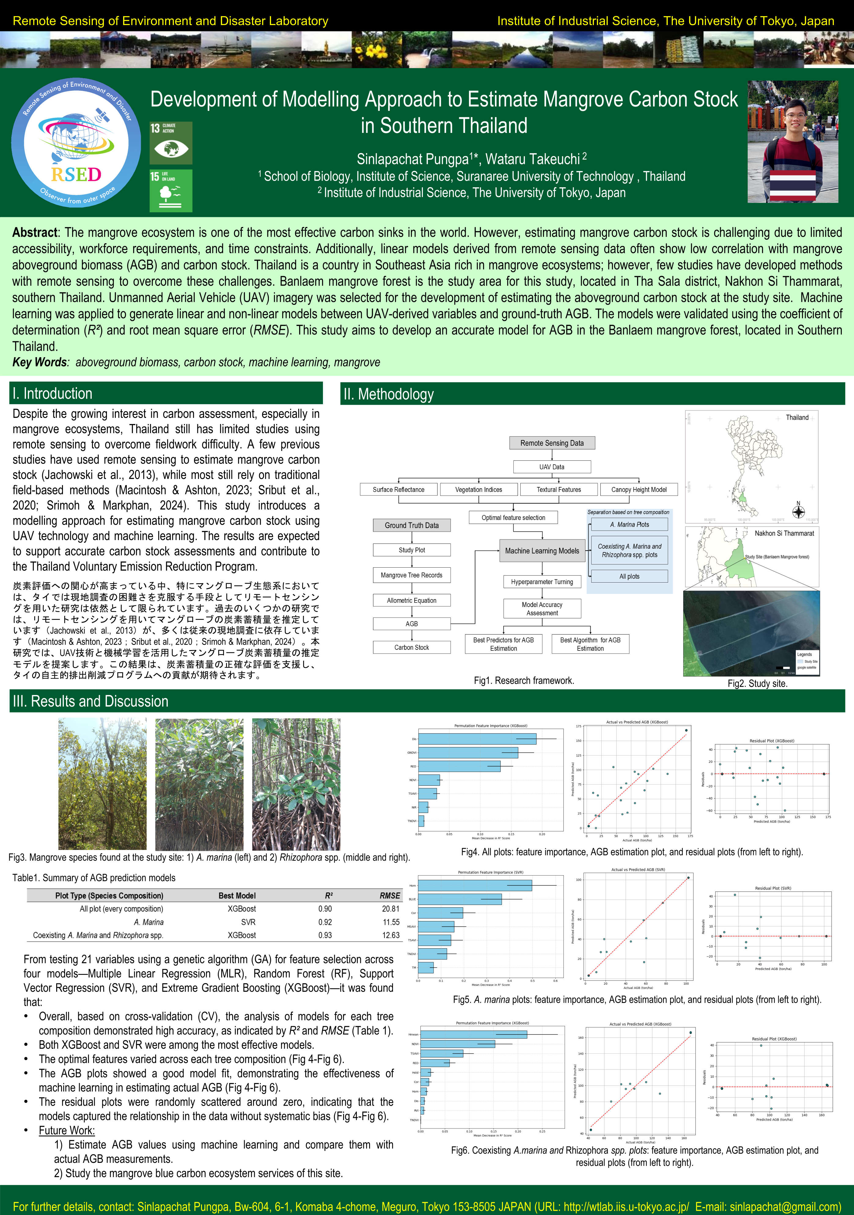
Development of Modelling Approach to Estimate Mangrove Carbon Stock in Southern Thailand [PDF] |
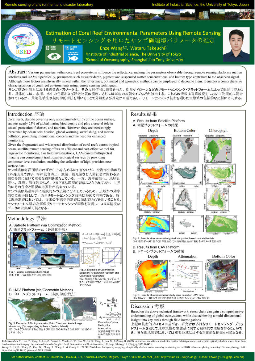
Estimation of Coral Reef Environmental Parameters Using Remote Sensing [PDF] |
Agriculture
Since the world's population increase, rice cultivation in South East Asia is an important industry as a food source. In this region, though the rice production mainly depends on the annual precipitation, the trend of decreasing is occurred due to the drought. In our laboratory we aim to estimate the rice harvest and develop cropping calendar using remote sensing technology.
 |
 |
 |
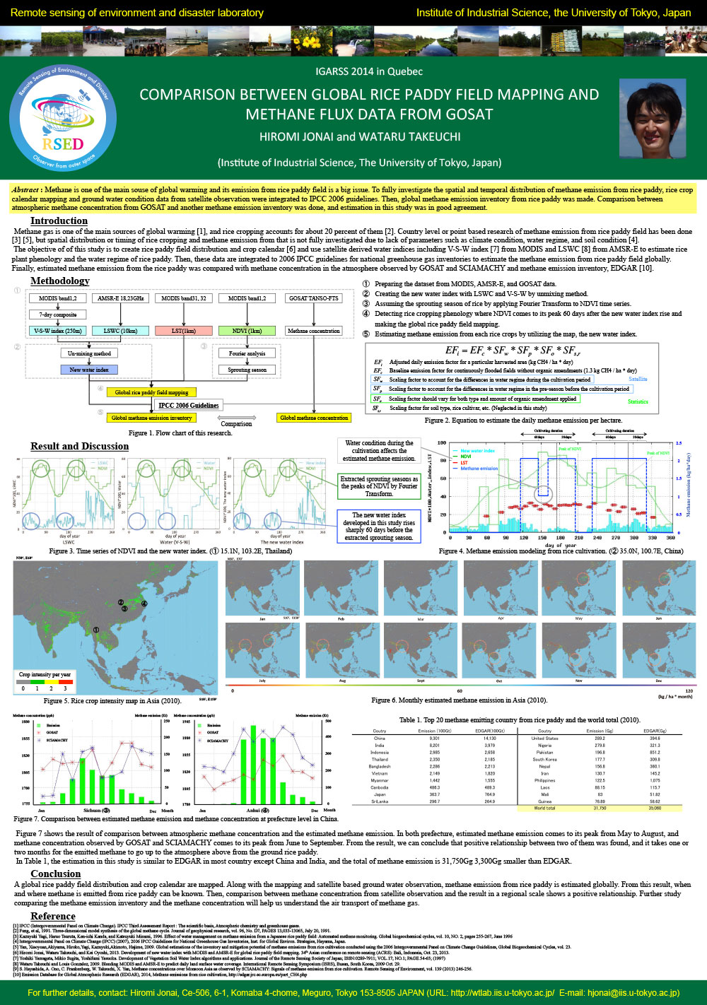
Comparison between global rice paddy field mapping and methane flux data from GOSAT [PDF] |
Spatio-temporally continuous evaluation on methane emission from tropical rice production [PDF] |
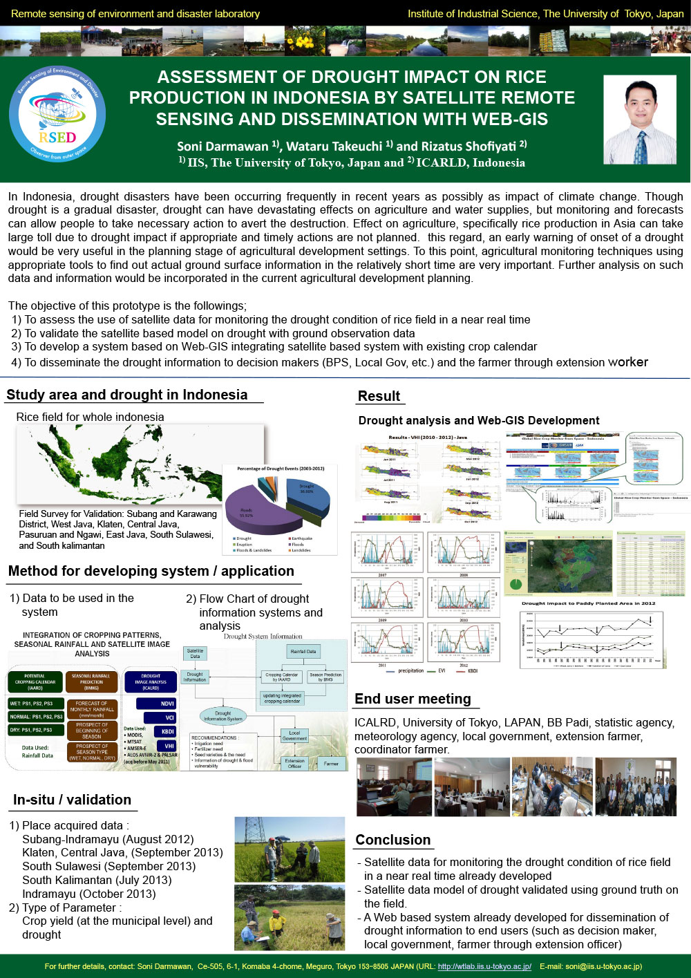
Assessment of drought impact on rice production in Indonesia by satellite remote sensing and dissemination with Web-GIS [PDF] |
 |
 |
 |
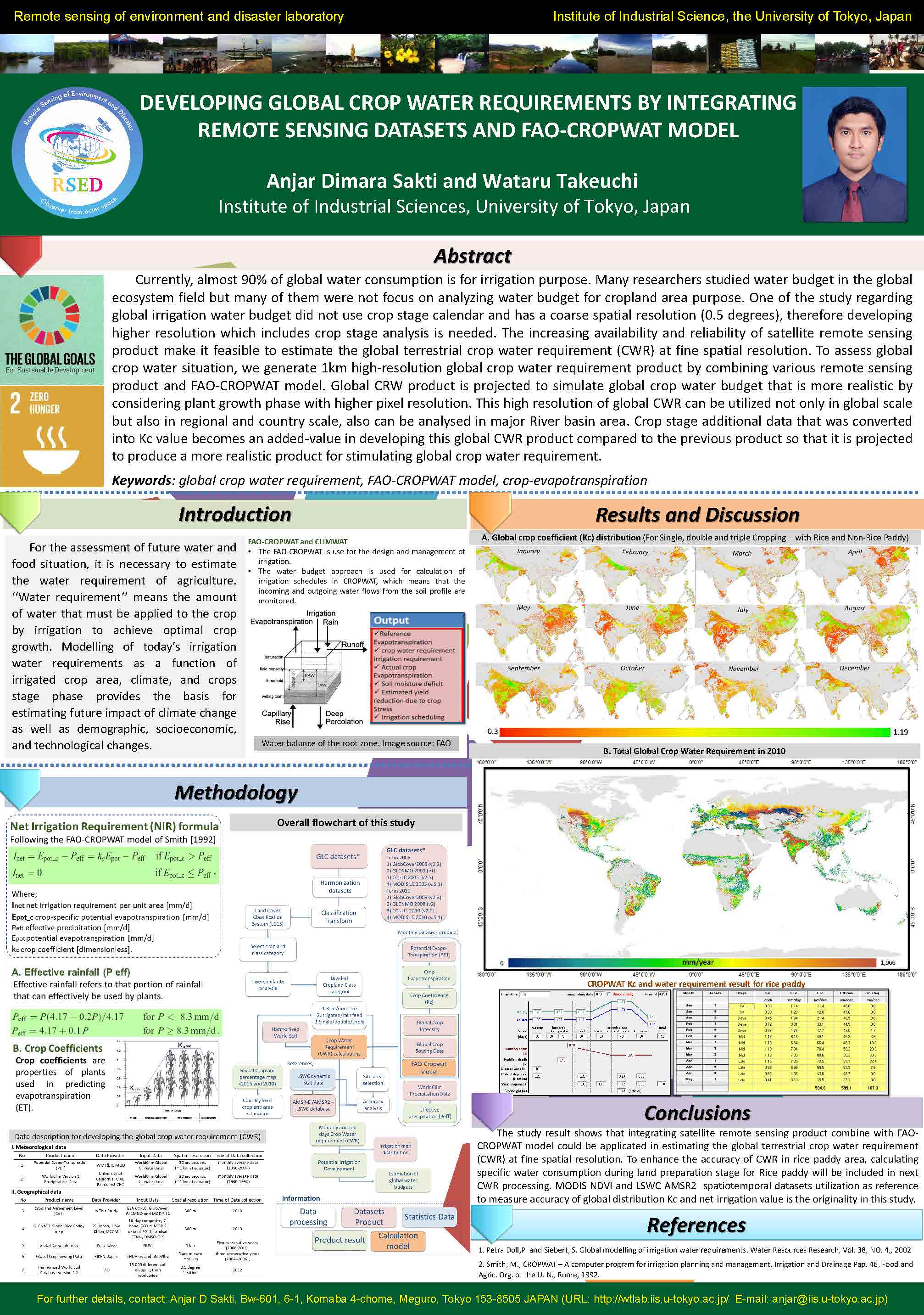
Developing the global crop water requirements simulation technique by integrating remote sensing datasets and FAO-CROPWAT model [PDF] |
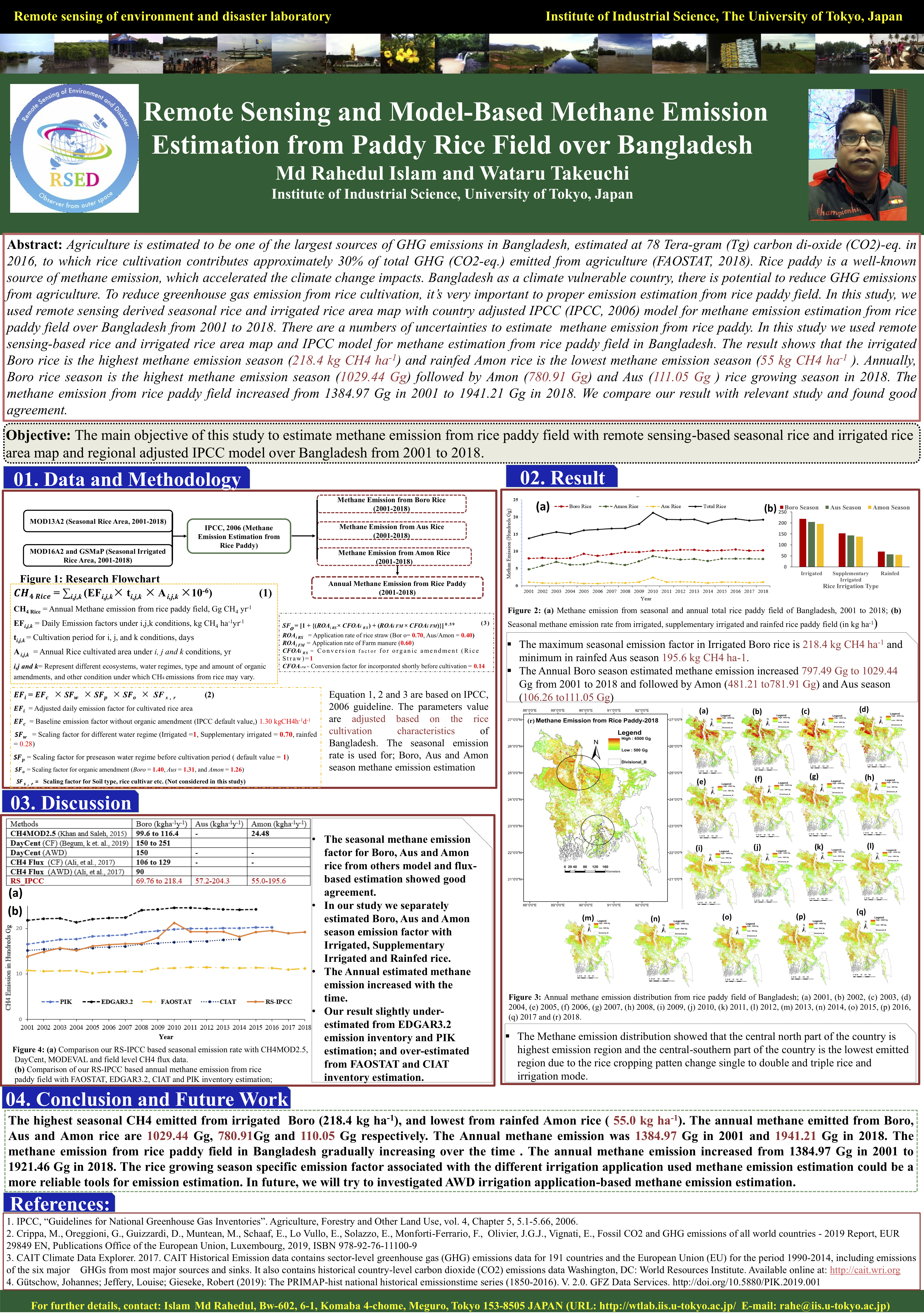
Remote Sensing and Model-Based Methane Emission Estimation from Paddy Rice Field over Bangladesh [PDF] |
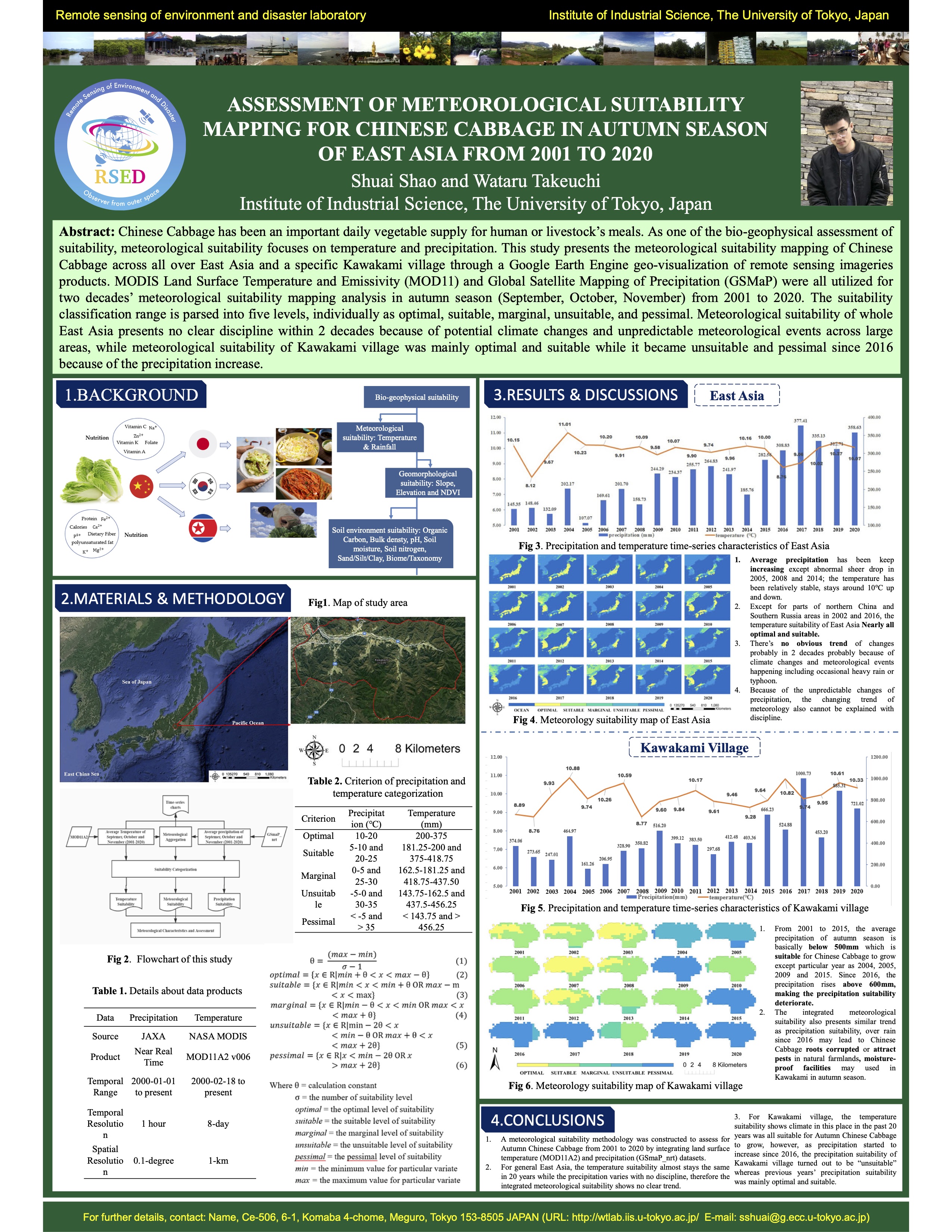
Assessment of meteorological suitability mapping for chinese cabbage in autumn season of east Asia from 2001 to 2020 [PDF] |
 |
 |
 |
Smartphone Application for Detecting and Visualizing Ganoderma Disease Stages in Oil Palm [PDF] |
Enhancing oil palm sustainability in Malaysia and Indonesia: identifying climate risks and automated replanting blueprint with remote sensing [PDF] |
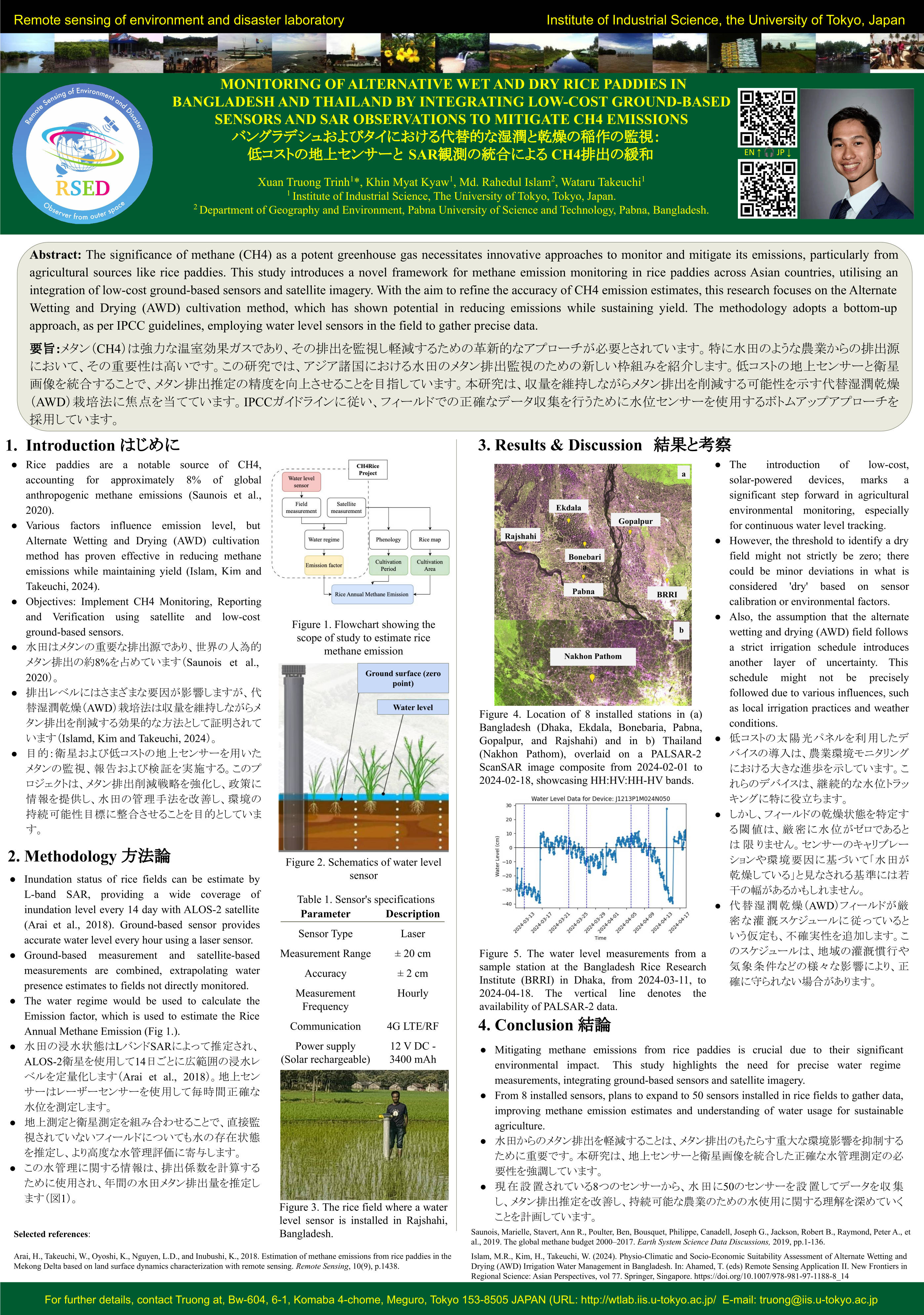
MONITORING OF ALTERNATIVE WET AND DRY RICE PADDIES IN BANGLADESH AND THAILAND BY INTEGRATING LOW-COST GROUND-BASED SENSORS AND SAR OBSERVATIONS TO MITIGATE CH4 EMISSIONS [PDF] |
 |
 |
|
Assessment of meteorogical suitability mapping for Chinese Cabbage in autumn season of East Asia from 2001-2020 [mp4] |
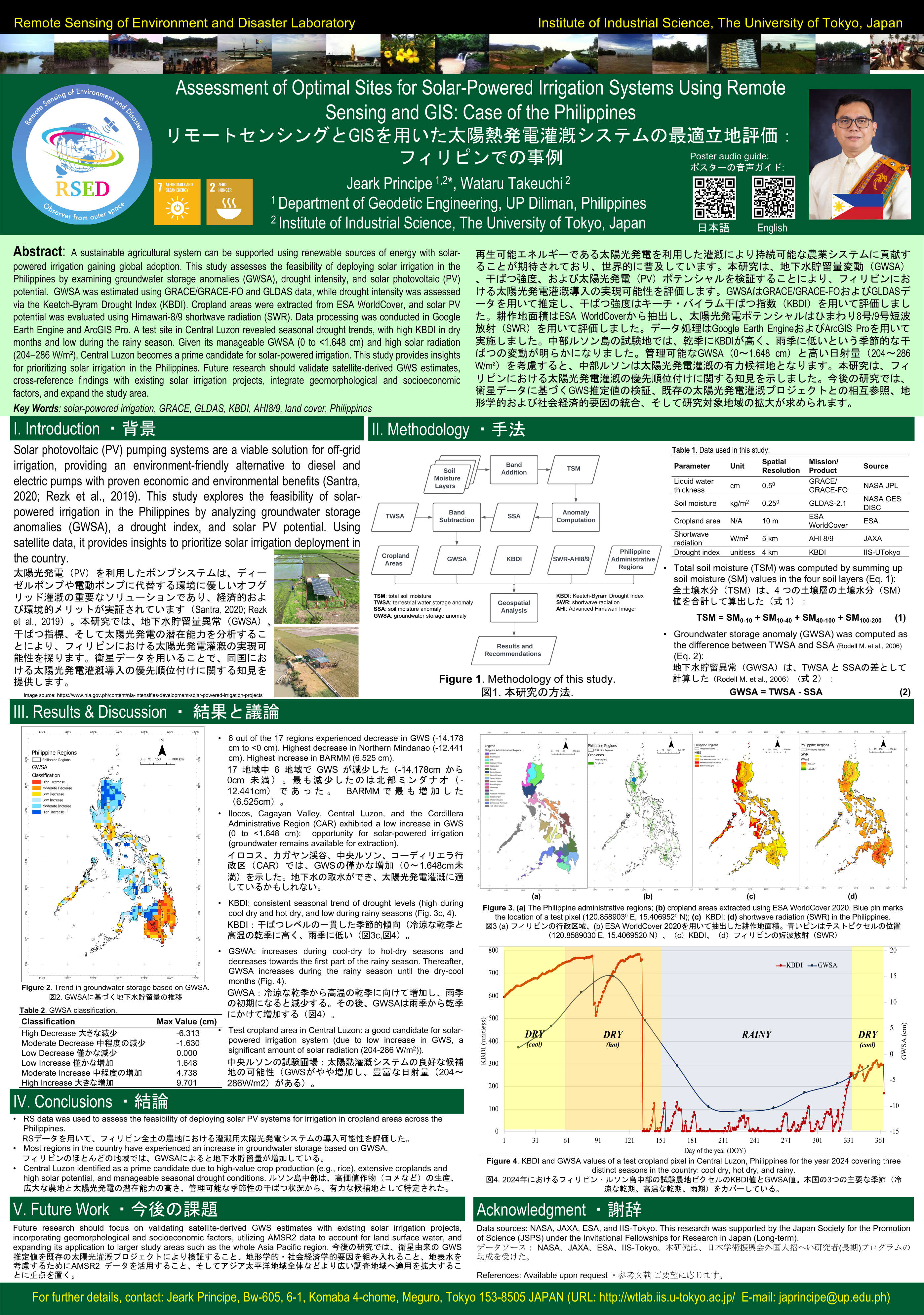
Assessment of Optimal Sites for Solar-Powered Irrigation Systems Using Remote Sensing and GIS: Case of the Philippines [PDF] |
Urban environmental assessment
It is important to understand environmental problems specific to urban area because of the urbanization have progressed in the world. With aid of satellite data we could estimate the temperature and humidity and analyze the characteristic of atmospheric condition in mega cities.
 |
 |
 |
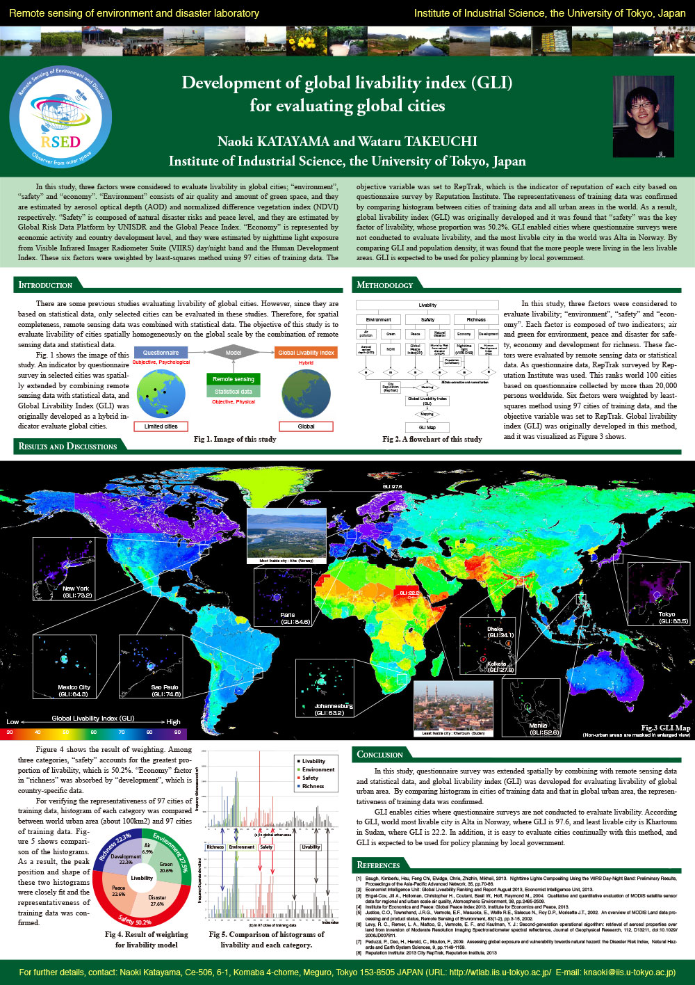
Development of global livability index (GLI) for evaluating global cities [PDF] |
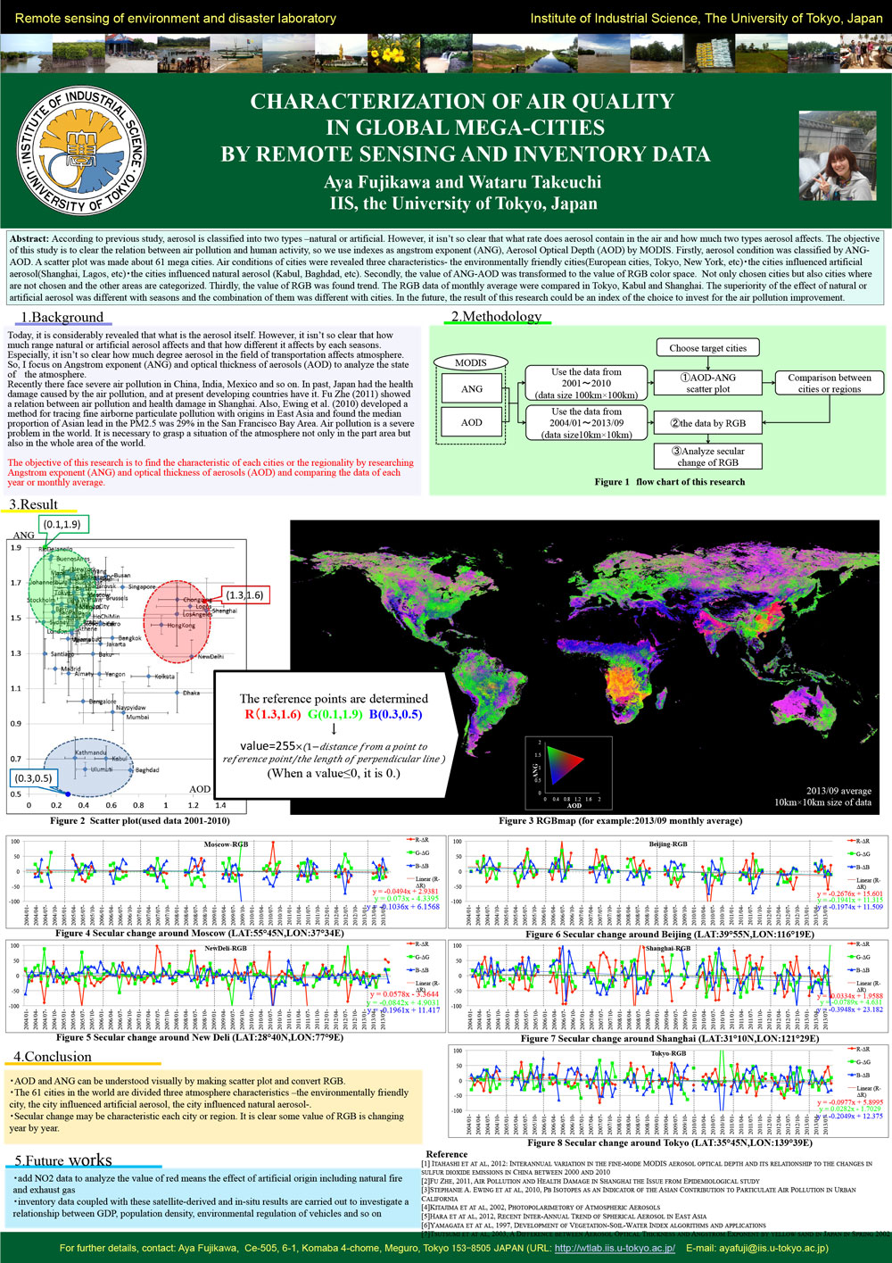
Characterization of air quality in global mega-cities by remote sensing and inventory data [PDF] |
Evaluating thermal comfort in city and its relation to socio economic activities [PDF] |
 |
 |
 |
Urban morphology identification using Digital Surface Model (DSM) over indian cities [PDF] |
Exploring nighttime lightes, MODIS global land cover and socio-economic datasets for electrification coverage and poverty mapping studies [PDF] |
Impacts of regional railways to the transigion of population, urban area and income in Australian cities [PDF] |
 |
 |
 |
Estimation of land price in Yangon, Myanmar based on empirical model using remotely sensed data [PDF] |
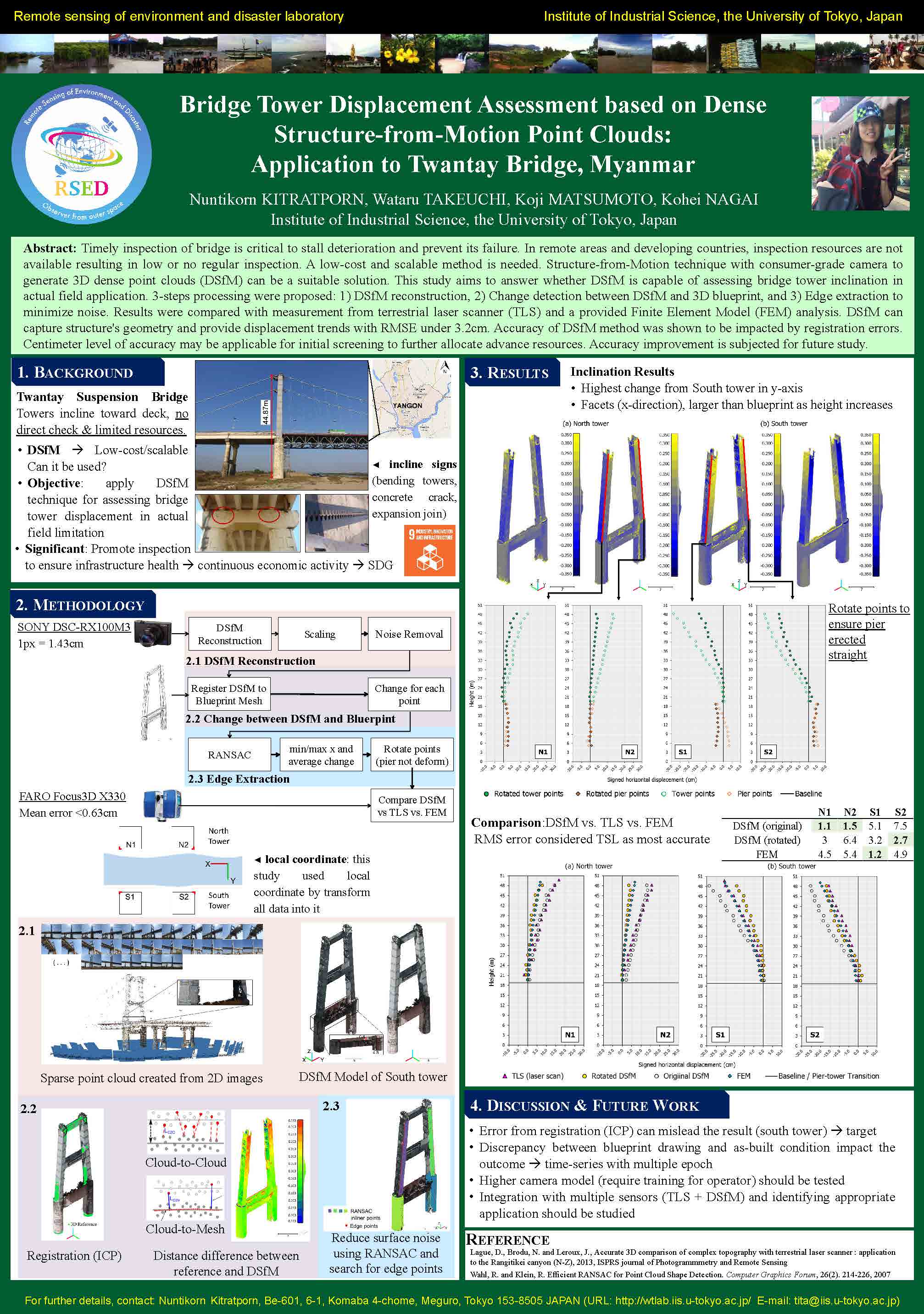
Bridge tower displacement assessment based on dense Structure-from-Motion point clouds: Application to Twantay Bridge, Myanmar [PDF] |
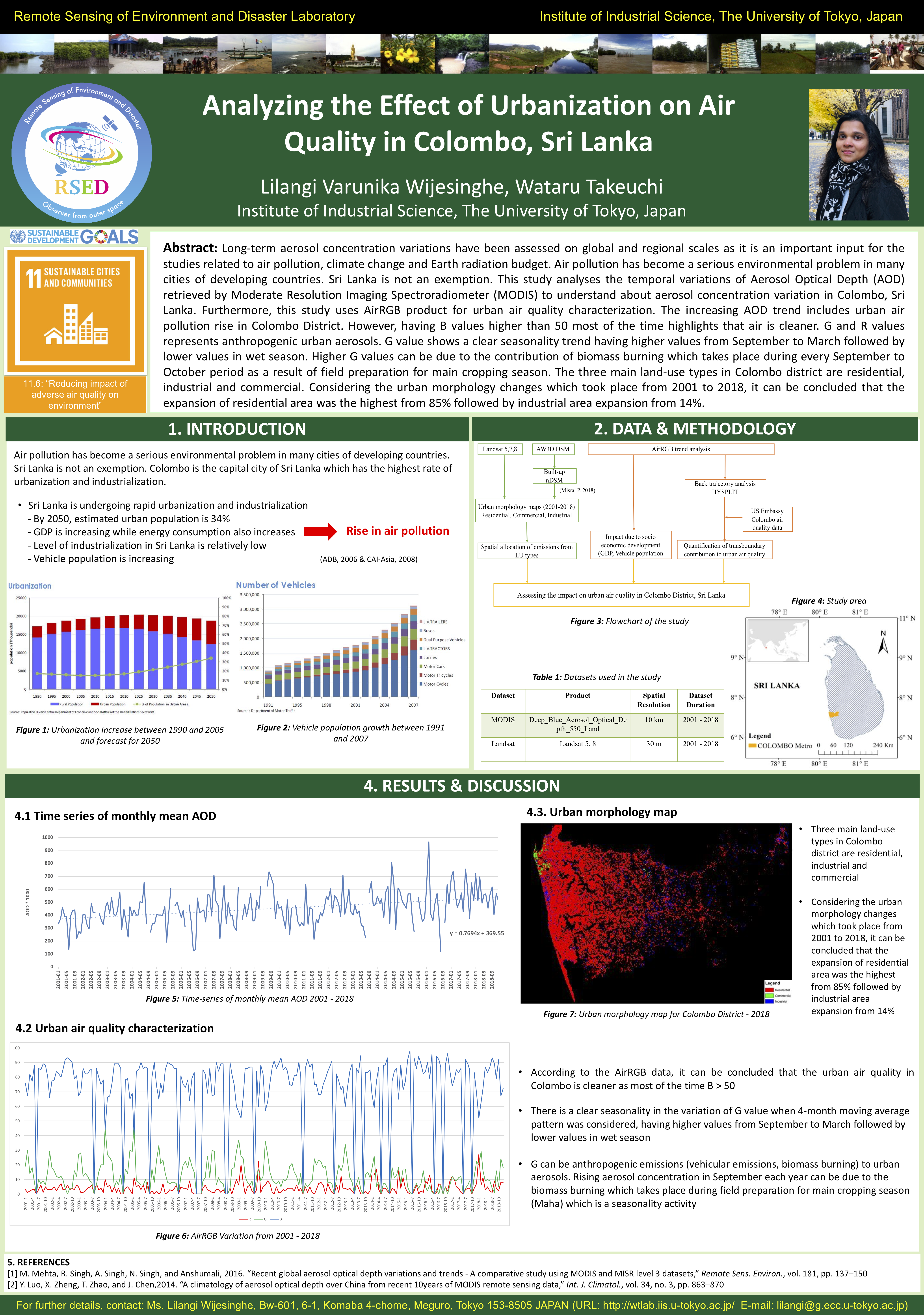
Analyzing the Effect of Urbanization on Air Quality in Colombo, Sri Lanka [PDF] |
 |
 |
 |
||
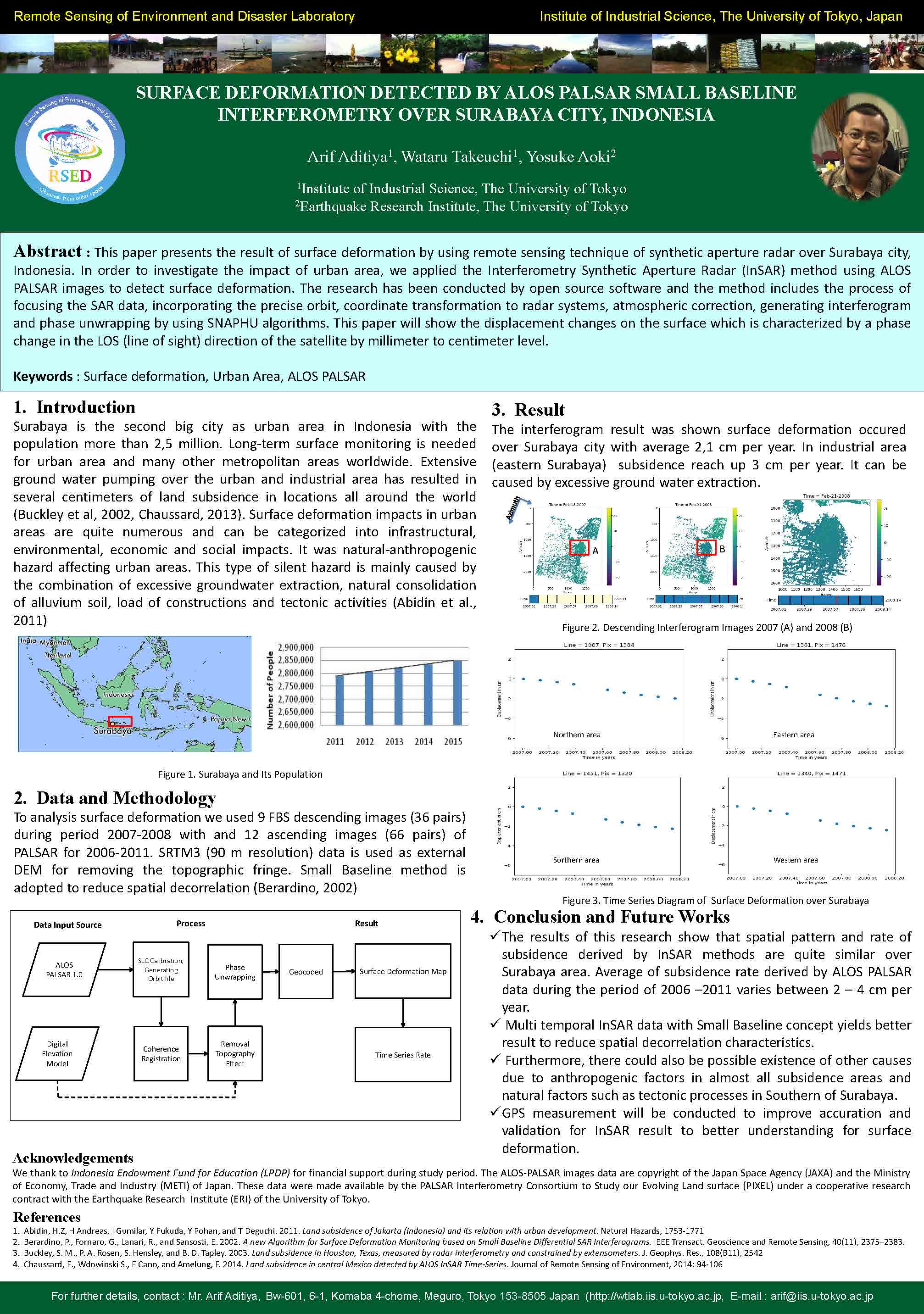
Surface Deformation Detected by ALOS PALSAR Small Baseline Subset Interferometry[PDF] |
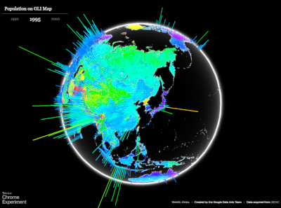
global livability index (GLI)map and population Works fine with Google Chrome[Map] |
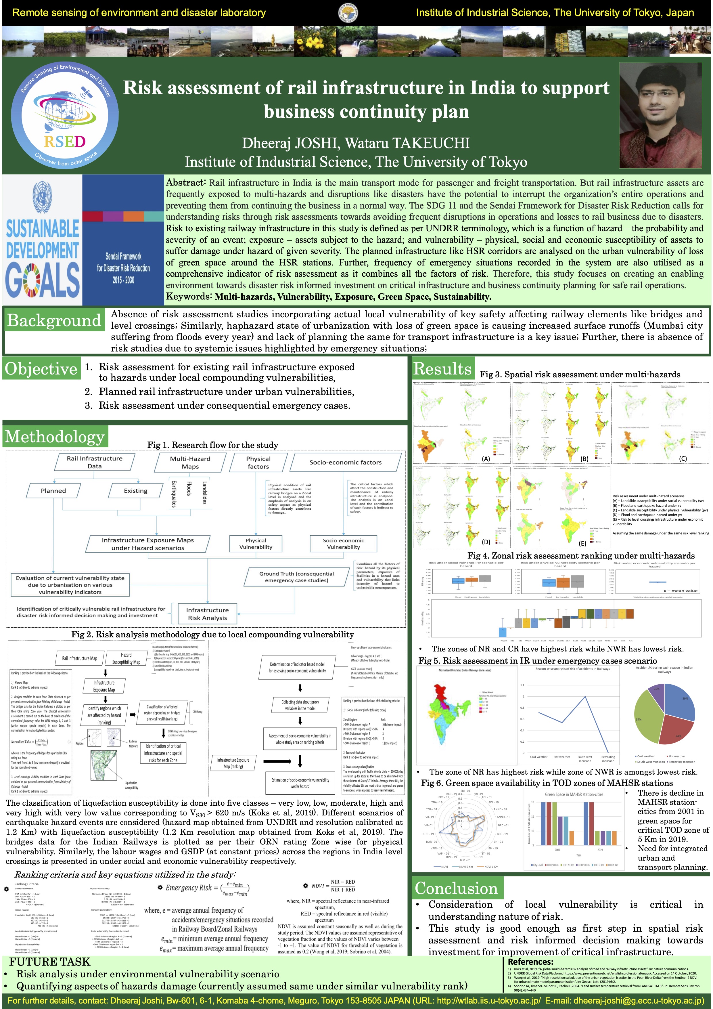
Risk assessment of rail infrastructure in India to support business continuity plan [PDF] |
 |
 |
 |
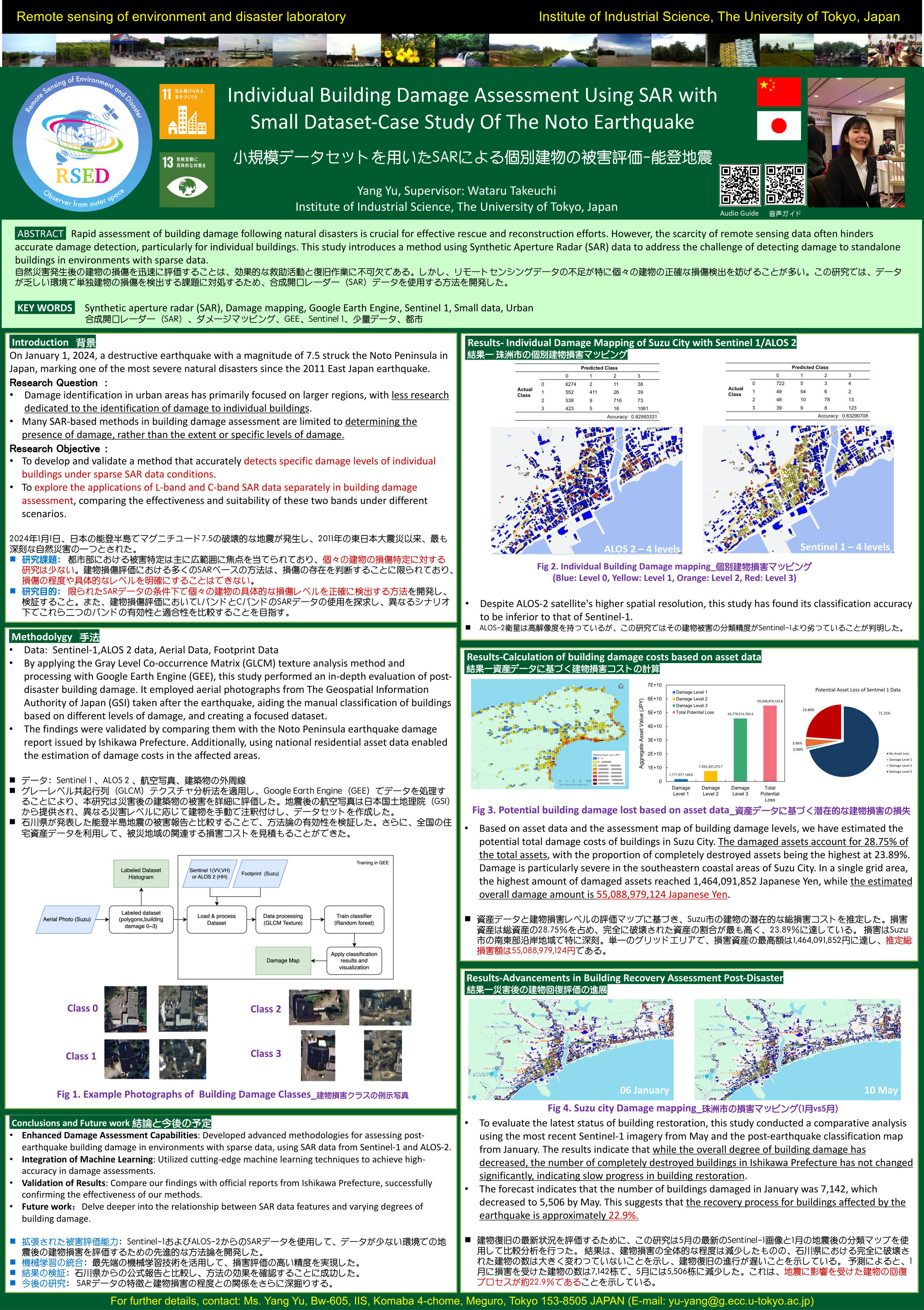
Individual Building Damage Assessment Using SAR with Small Dataset-Case Study Of The Noto Earthquake[PDF] |
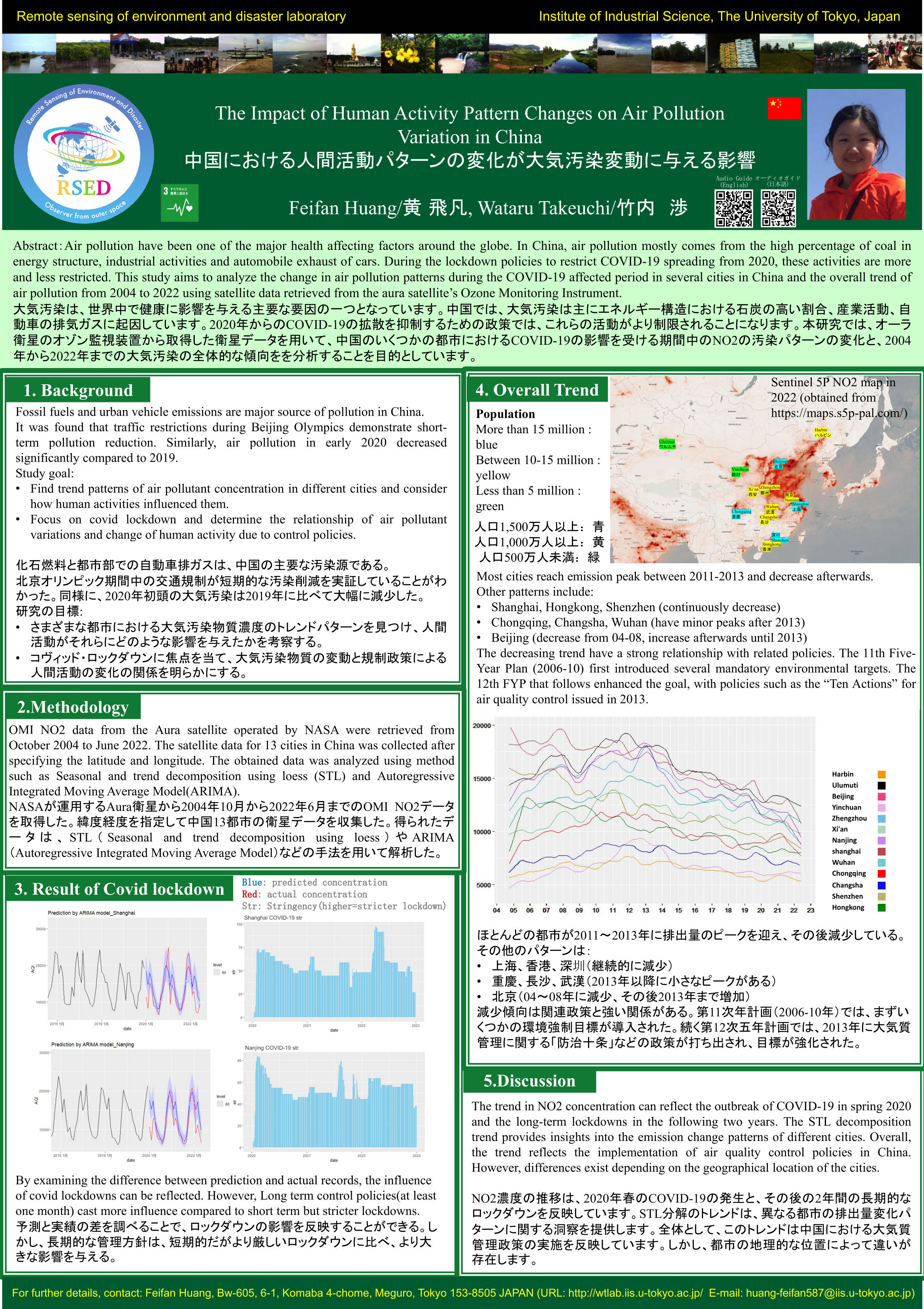
The Impact of Human Activity Pattern Changes on Air Pollution Variation in China [PDF] |
Analysis of temporal and spatial characteristics of informal economic activity and pedestrian sidewalk space-sharing in urban areas of Vietnam[PDF] |
 |
 |
|
Quantitative analysis on the spatiotemporal pattern of solar PV installation and their impacts on the land-cover using satellite timeseries data in Asia pacific region[PDF] |
Automatic processing for GIS data conversion of Gaihōzu[PDF] |
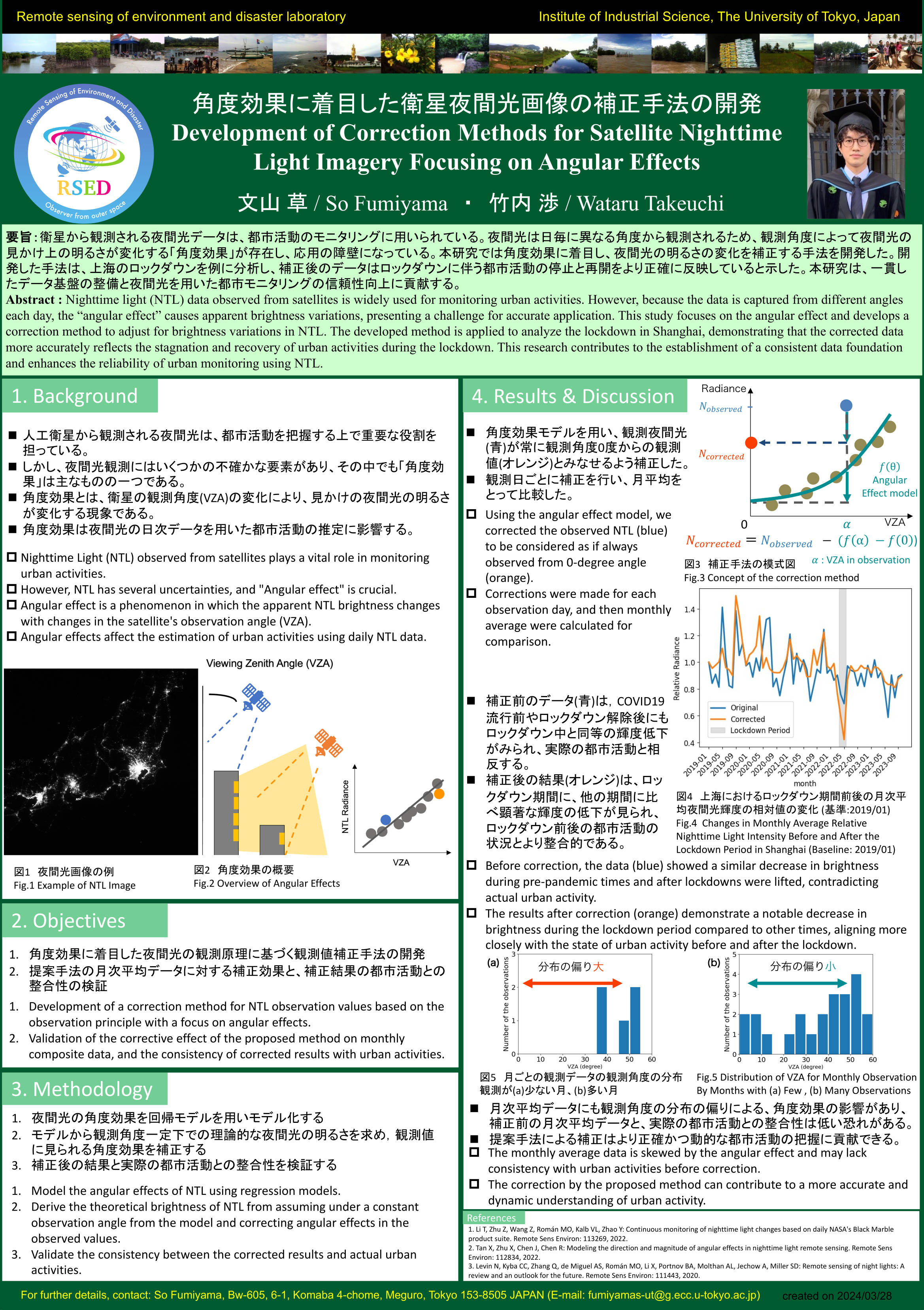
Development of Correction Methods for Satellite Nighttime Light Imagery Focusing on Angular Effects[PDF] |
 |
 |
 |
Quantitative Evaluation of Green Space Environmental Changes Accompanying Urban Compaction[PDF] |
Evaluating Urban Facade Strategies for Solar and Heat Optimisation: A Remote Sensing and 3D Simulation Study of the Roppongi Hills [PDF] |
Development of a School District Allocation Model Considering Urban Environment and Population Dynamics Forecasts [PDF] |
Infrastructure health monitoring
Infrastructure health monitoring is crucial for maintaining the safety and functionality of critical structures such as bridges, dams, and buildings. By utilizing advanced sensor technology, satellite data, and data analytics, we can detect early signs of wear, damage, or potential failure..
 |
 |
 |
Integration of Satellite based Deformation Data in Structural Health Monitoring System of Transport Infrastructures(Case Study of Roadway Networks in Myanmar)[PDF] |
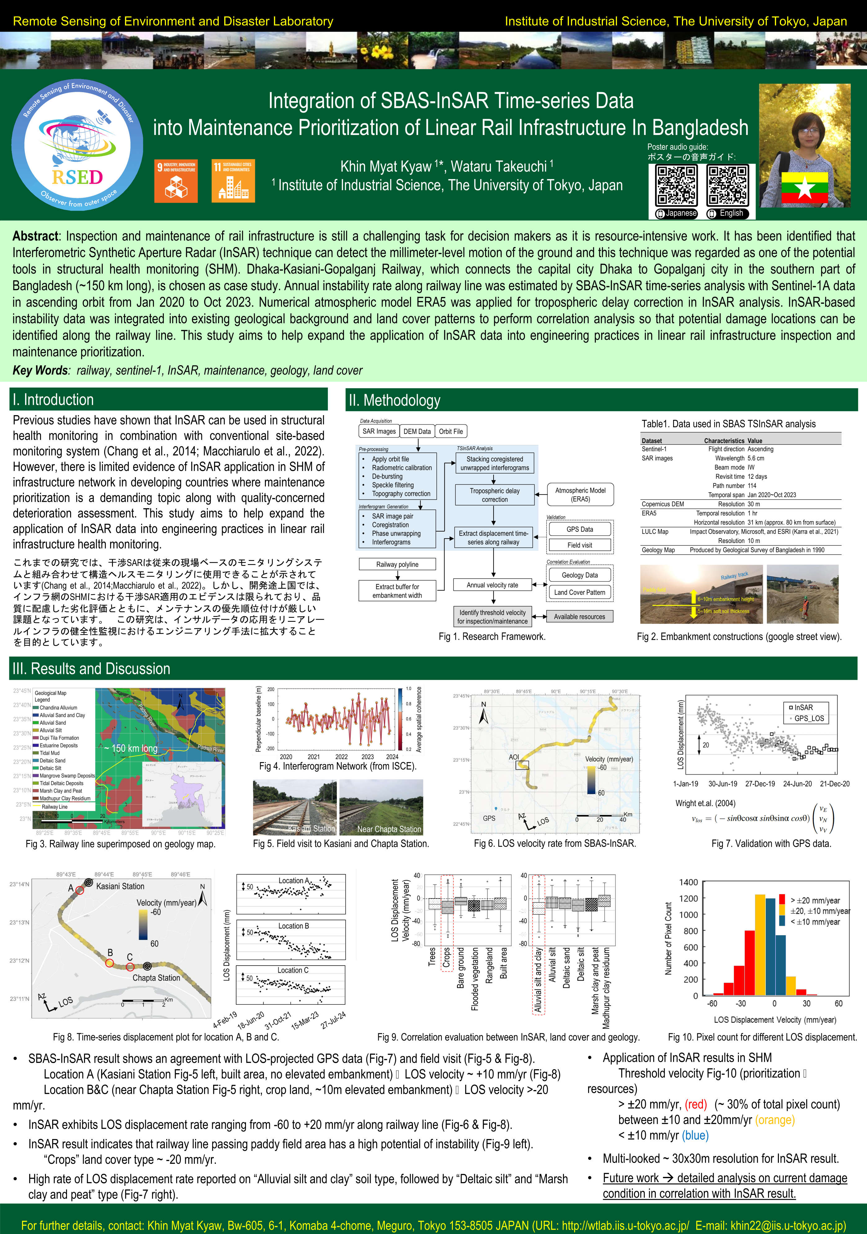
Integration of SBAS-InSAR Time-series Data into Maintenance Prioritization of Linear Rail Infrastructure In Bangladesh [PDF] |
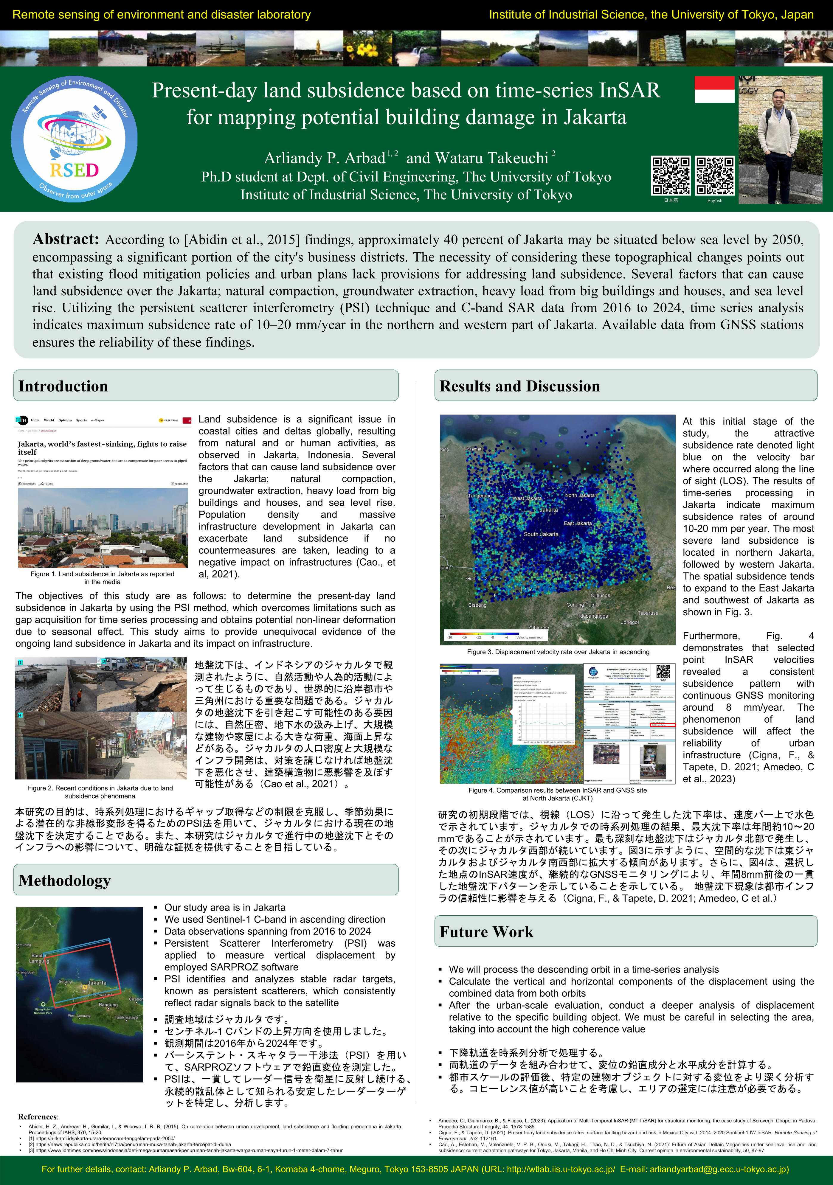
Present-day land subsidence based on time-series InSAR for mapping potential building damage in Jakarta[PDF] |
 |
 |
 |
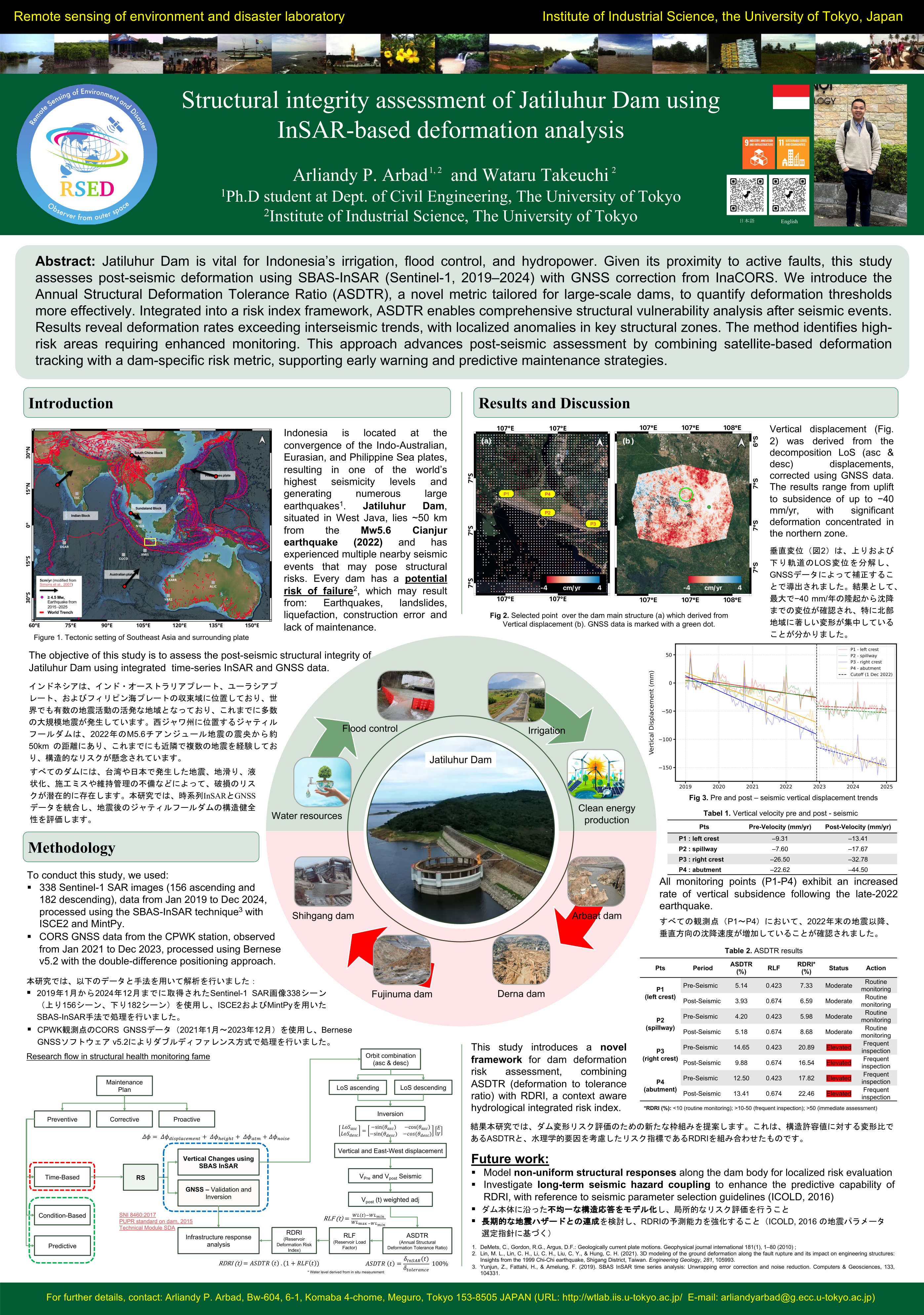
Structural integrity assessment of Jatiluhur Dam using InSAR-based deformation analysis[PDF] |
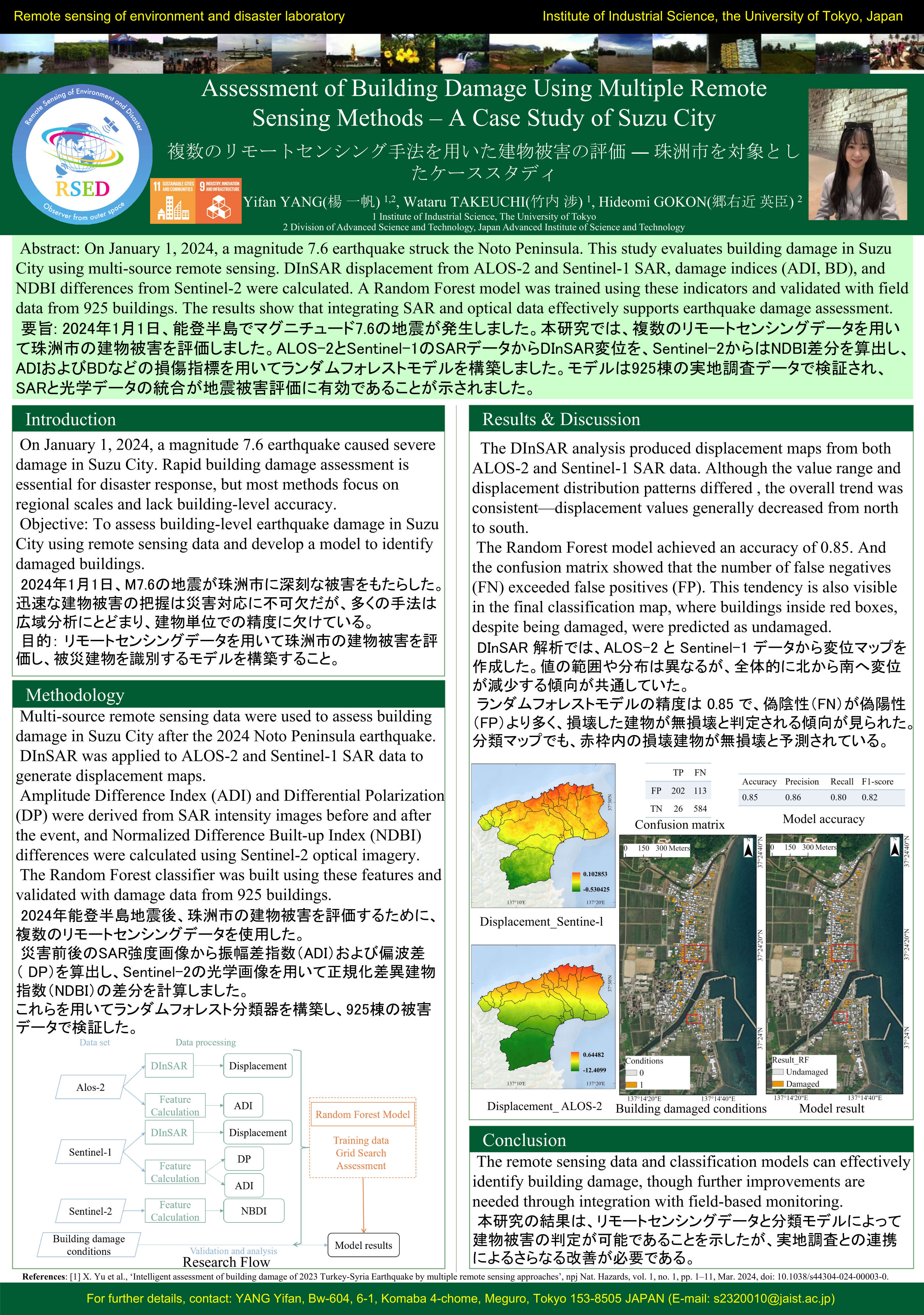
Assessment of Building Damage Using Multiple Remote Sensing Methods – A Case Study of Suzu City[PDF] |
Risk analysis of rail infrastructure in India under multi-hazard and consequential emergency cases scenario [mp4] |
Natural disaster
Due to the global warming combined with excessive human activities, various natural disasters happened all over the world. It was not only a threat to human life, but also related losses in infrastructure and economy.
In our laboratory, with use of modern computing power, we develop a new framework to detect the natural disaster、carry out disaster forecasting and evaluation by integrating real-time computing, remote sensing and GIS.
 |
 |
 |
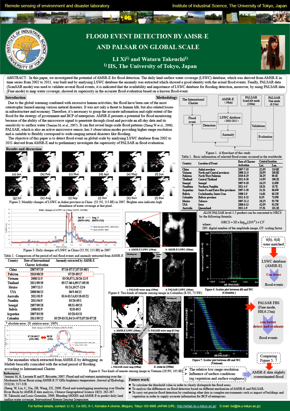
Flood event detection by AMSR-E and PALSAR on global scale [PDF] |
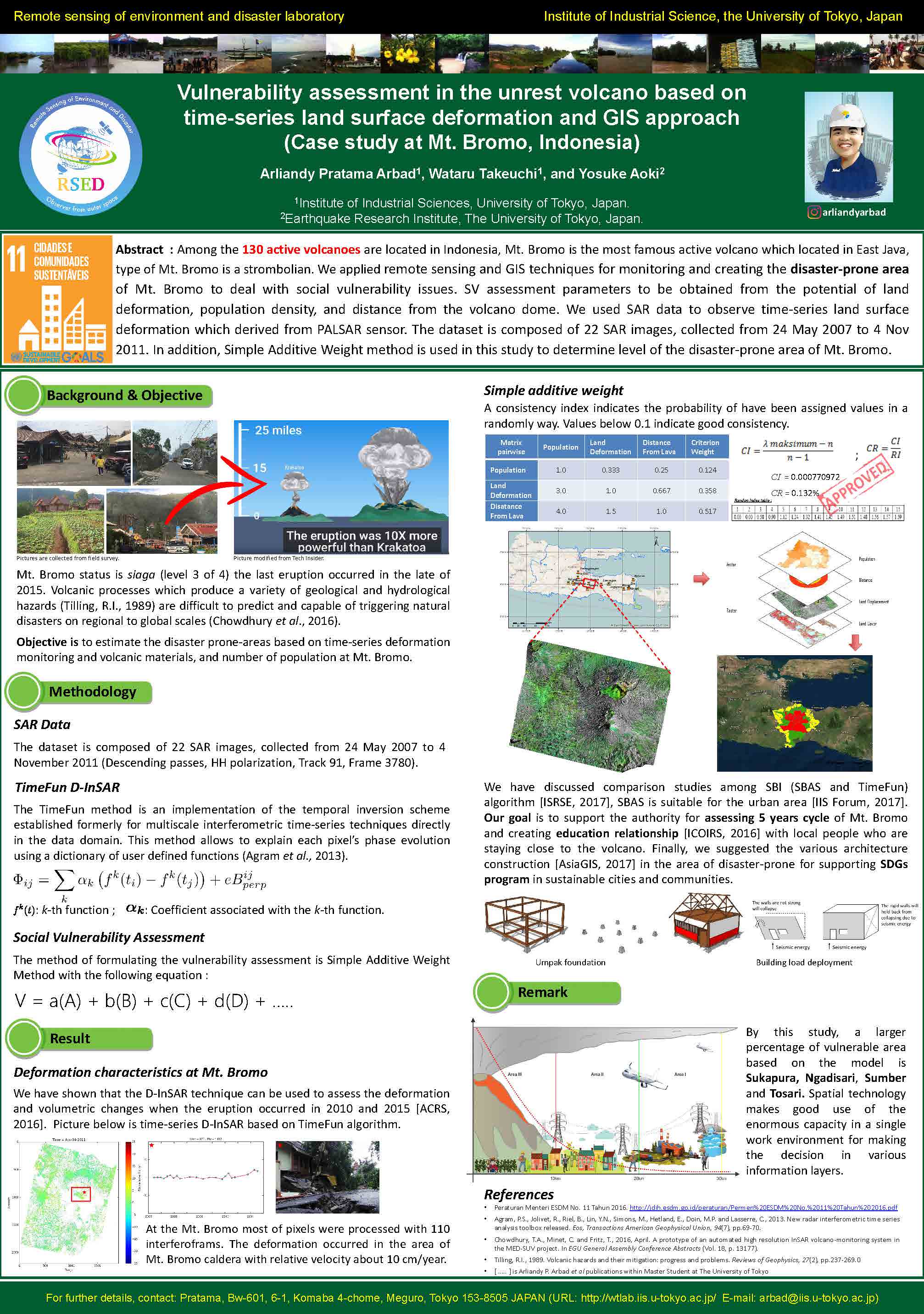
Vulnerability assessment in the unrest volcano based on time-series land surface defomation and GIS approach (Case study at Mt. Bromo, Indonesia) [PDF] |
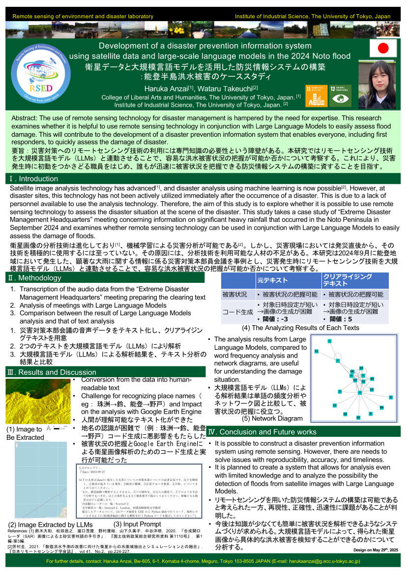
Development of a disaster prevention information system using satellite data and large-scale language models in the 2024 Noto flood [PDF] |
 |
||
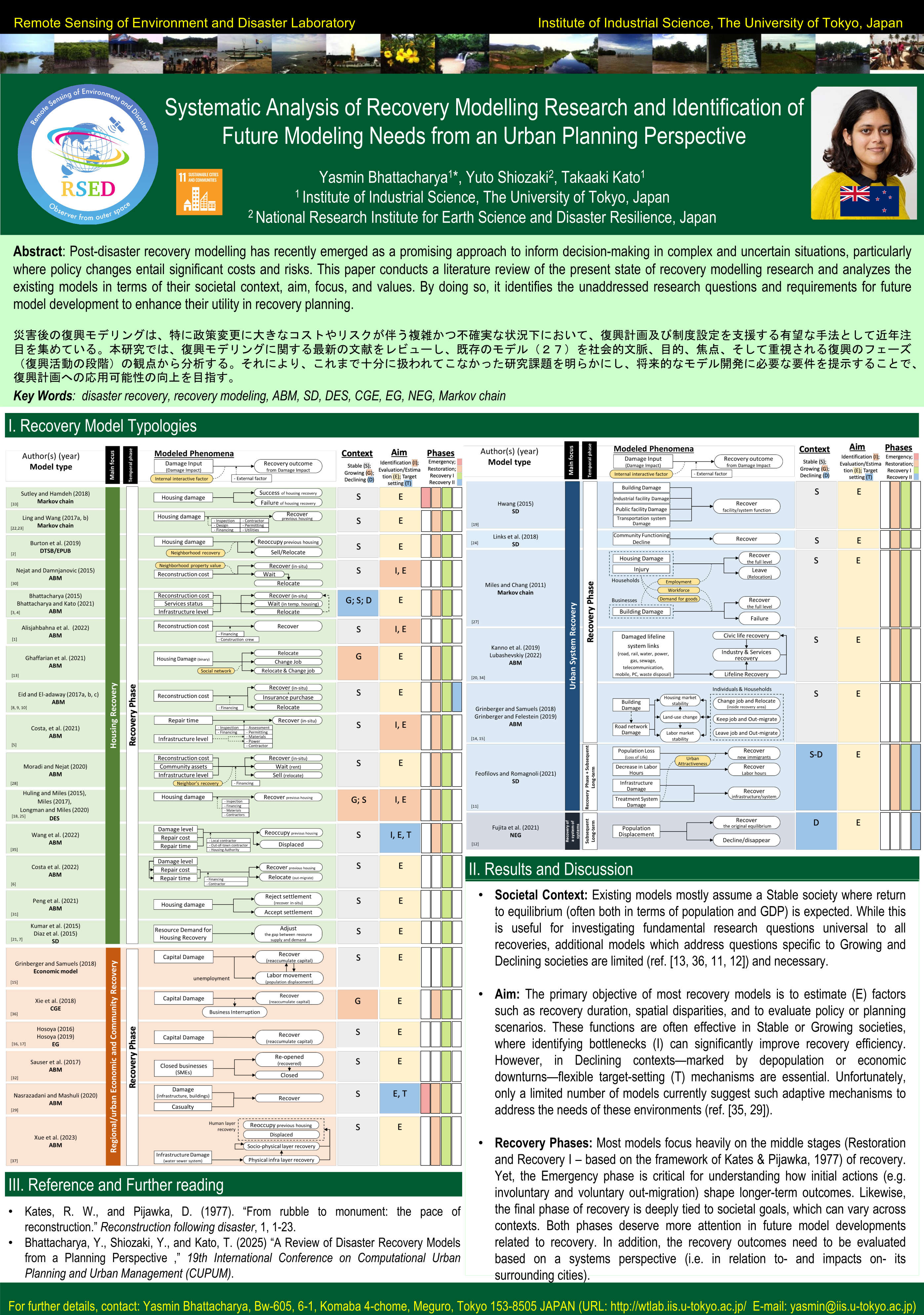
Systematic Analysis of Recovery Modelling Research and Identification of Future Modeling Needs from an Urban Planning Perspective[PDF] |
Field survey
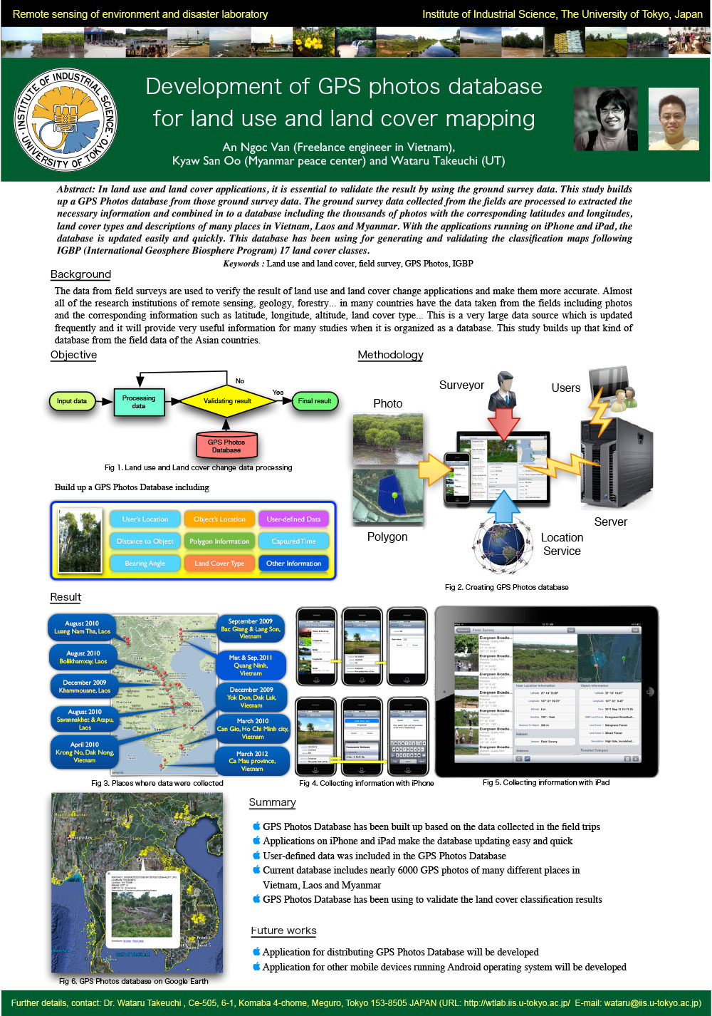
In situ measurements are important to carry out accuracy assessment for the retrieval data from satellite images. In this case developed GPS photo database software can be used to understanding the land use land cover types where the measurements have been took place. Moreover we aim to estimate the grassland biomassrice by combining satellite and in-situ measurement data.
 |
 |
|
Development of GPS photos database for land use and land cover mapping [PDF] |
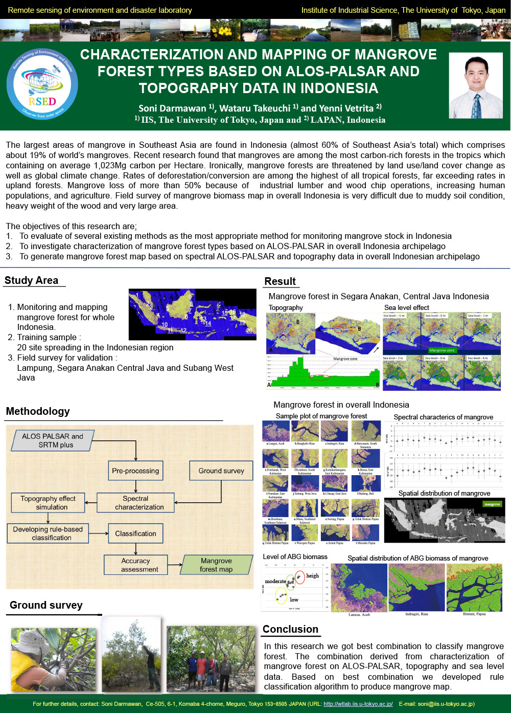
Characterization and mapping pf mangrove forest types based on ALOS-PALSAR and topography data in Indonesia [PDF] |